Над 4 милиона заглавия на английски и други езици! Открийте новата си история още днес! Безплатна доставка за поръчки над 69.99€
Станете част от общност от любители на книгите от цял свят и получавате много предимства.
Създай на безплатен акаунт
Безплатна доставка със Еконт над 69.99 €
Куриер Speedy 3.49 €
Пункт на Speedy 3.49 €
ЕКОНТ 3.99 €
Еконтомат/Офис на Еконт 3.99 €
Ekont Box 3.99 €
Sameday 3.99 €
Sameday box 3.99 €
Box Now 3.99 €
 Контакт
 Как се пазарува?
Помощ
Доставка
Куриер Speedy 3.49 €
Пункт на Speedy 3.49 €
ЕКОНТ 3.99 €
Еконтомат/Офис на Еконт 3.99 €
Ekont Box 3.99 €
Sameday 3.99 €
Sameday box 3.99 €
Box Now 3.99 €
Безплатна доставка със Еконт над 69.99 €
Наръчник за пазаруване
Моят акаунт
▸
Празна :-(
0
Над 4 милиона заглавия на английски и други езици! Открийте новата си история още днес! Безплатна доставка за поръчки над 69.99€
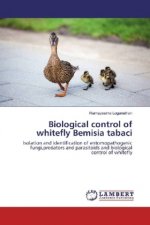
Remote Sensing and GIS Based Lithological Mapping
Език
 Английски език
Английски език
Книга
С меки корици
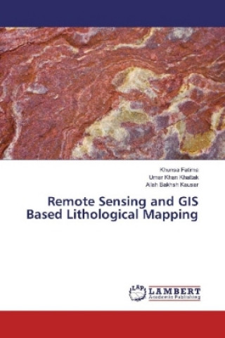
Remote sensing and GIS techniques assist geologists by providing valuable information about geology...
Цялото описание
Код Либристо: 16045147
?
 94 b
94 b
94 b
38.83
€
75.94
лв
Налично при издателя, по поръчка
Изпращаме след 17-27 дни
30 дни за връщане на стоката
Клиентите са закупили също

 /
/
 С меки корици
 42.09
€
82.32 лв
42.09
€
82.32 лв


 /
/
 Календар
35.15
€
68.75 лв
Календар
35.15
€
68.75 лв


 /
С меки корици
23.29
€
45.56 лв
/
С меки корици
23.29
€
45.56 лв
 /
С меки корици
35.72
€
69.86 лв
/
С меки корици
35.72
€
69.86 лв
 /
С меки корици
15.53
€
30.37 лв
/
С меки корици
15.53
€
30.37 лв


 /
С меки корици
17.13
€
33.51 лв
/
С меки корици
17.13
€
33.51 лв


 /
С меки корици
12.73
€
24.90 лв
/
С меки корици
12.73
€
24.90 лв

 /
С меки корици
14.85
€
29.05 лв
/
С меки корици
14.85
€
29.05 лв

Remote sensing and GIS techniques assist geologists by providing valuable information about geology and minerals of an area to be surveyed, so that geologists spend quality and focused time in the field. The lithology of Khaira Murat Range, Attock Pakistan is studied using Landsat ETM+ and ASTER Satellite images. The shortwave infrared and thermal infrared bands of Landsat and ASTER successfully mapped industrial minerals like calcite, quartz, muscovite and montmorillonite.
Героиня
&
Полиглот
EWA KASP
за
Пусни видеото


В Libristo има най-богатия избор от чуждоезична литература. Затова купувам книгите си тук.
Информация за книгата
Пълно заглавие
Remote Sensing and GIS Based Lithological Mapping
Език
Английски език
Английски език
Корици
Книга - С меки корици
Дата на издаване
2017
Брой страници
68
Баркод
9783330045781
Код Либристо
16045147
Издателство
LAP Lambert Academic Publishing
Тегло
119
Размери
150 x 220 x 4

Подарете тази книга днес
Лесно е
1 Добавете книгата в количката си и изберете Доставка като подарък 2 В замяна ще ви изпратим ваучер 3 Книгата ще пристигне на адреса на получателяМоже би ще Ви заинтересува

 /
С меки корици
53.58
€
104.80 лв
/
С меки корици
53.58
€
104.80 лв


 /
С меки корици
15.79
€
30.87 лв
/
С меки корици
15.79
€
30.87 лв
 /
С твърди корици
38.31
€
74.92 лв
/
С твърди корици
38.31
€
74.92 лв


 /
/
 Adobe ePub DRM
4.60
€
9.00 лв
Adobe ePub DRM
4.60
€
9.00 лв
 /
С меки корици
60.68
€
118.67 лв
/
С меки корици
60.68
€
118.67 лв


 /
С твърди корици
61.14
€
119.58 лв
/
С твърди корици
61.14
€
119.58 лв

Книжен съветник Libroamiko
Използвайки този чат, вие комуникирате с генеративен изкуствен интелект. Използвайки го, вие също се съгласявате с обработката на лични данни.
Здравейте! Аз съм Libroamiko, вашият книжен съветник.
Как мога да ви помогна?
Здравейте, аз съм Libroamiko, мога ли да помогна?